Horizontal and Slope Lines
The Slope and Contour curve
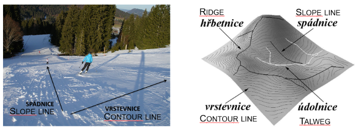
The contour lines (or curves) of a surface are the sections of this surface by the horizontal planes (i.e. perpendicular to the vertical direction). The contour lines of a plane are called horizontal (principal) lines.
Contours are one of several common methods used to denote elevation or altitude and depth on maps.
Contour lines of topographic surface are closed curves surrounding summits or immits.
Contour lines at surface of equal slope (plane, cone,...) are equidistant.
The slope lines ( = lines of the steepest descent) cut at right angles the contour lines; and this property applies also to the top view projection.

Horizontal and slope lines in a plane
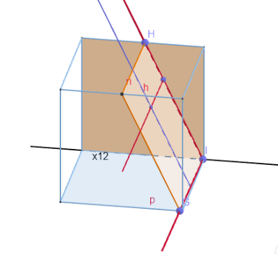
Plane is given by points GHI on the cube. Horizontal projection plane is blue face of a cube, frontal projection plane is red face. The base (ground) line x12 is intersection line of projection planes, i.e.. Trace lines of the planes n, p are lines where the plane meets the planes of projections, i.e. and .
- Horizontal line h of a plane is parallel to the blue face.
- The line of steepest descent s (=slope line) is perpendicular to the horizontal line h. This line determines the slope angle of the plane. The right angle between lines s and h has true size in top view, i.e. - tool
 .
.
Geotest 4136
In given point A of plane α construct the first steepest line s (i.e. both projections s1, s2). A horizontal line h and frontal line f of the plane are given. (GeoTest)
Solution:
First slope line s is perpendicular to horizontal line h in top view. Choose arbitrary point and determine auxiliary first slope line as passing through a point H. First slope line is perpendicular to horizontal line in top view. Lines of steepest descent are mutually parallel, .
Step 2: Arbitrary , top view of auxiliary first slope as
Steps 3, 4: Front view of intersection points H, F .
Step 5: Front view of auxiliary slope line as = H2F2.
Step 6: Slope line s is parallel with auxiliary slope line as in both views .
Geotest 4120
Construct a line of the steepest descent (both projections s1, s2) in the point A of given plane α orthogonal to the vertical plane of projection. The trace n of the plane α is given (GeoTest).
